News | February 8, 2009
New view of smoke from wildfires

|

|
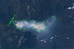
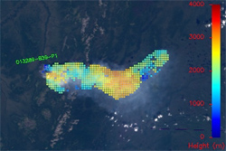
Observations from NASA's Multi-angle Imaging SpectroRadiometer (MISR) show that the plumes of dust, smoke and particles from wildfires or volcanoes often rise past the atmospheric boundary layer, the turbulent lowest portion of the atmosphere, and are injected into the less-turbulent and higher free troposphere. The aerosols can remain concentrated there for long periods and also be transported great distances.
The MISR Plume Height Climatology Project, a repository for wildfire plume height data acquired with MISR, became publically available in early 2008 and supports studies of wildfires, climate change and air quality. The MISR INteractive eXplorer (MINX) application tool used to generate the database is also free and was the recipient of a 2008 NASA Space Act Board Award.
One of the project's goals is to generate data based on actual observations of biomass burning emissions from wildfires that can be used in global atmospheric models. The frequency of wildfires has increased over the past few decades, and such fires may be even more common in a future, warmer climate. Predicting the effects of climate change on air quality requires the ability to accurately model smoke injection and long-range transport.
The MISR instrument flies on NASA's Terra satellite.
| The research paper: |
| Related research papers: |
Mission provides tools to improve cloud models

One challenge has been the lack of adequate, high-quality, global observations targeting the vertical structure of clouds and their associated precipitation. It has also been difficult to make meaningful comparisons between idealized depictions of clouds in climate models and actual measurements of cloud properties from satellites.
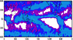
JPL researchers Jui-Lin F. Li, Christopher Woods and Duane Waliser and a group of their colleagues have developed new methods using radar data from NASA's CloudSat satellite on cloud type and ice content to improve how clouds are represented in climate models and help validate models' results. The result should be more agreement between the models and the observations and less uncertainty on the course of future climate.
The researchers' findings appear in a series of papers in Geophysical Research Letters and the Journal of Geophysical Research.
| The research paper: |
| Related research papers: |
Changes in ocean mass linked to El Niño

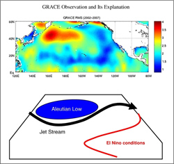
Using new data from NASA's twin GRACE satellites, JPL researchers Y. Tony Song and Victor Zlotnicki found a strong oscillation in ocean bottom pressure between the subpolar and subtropical gyres of the North Pacific, that takes place at the same time as the El Niño/Southern Oscillation. By examining atmospheric circulation, sea surface altimetry data and an ocean circulation model, they confirmed that this change in ocean bottom pressure is the result of the El-Niño/Southern Oscillation, which deepens the Aleutian Low, the center of low atmospheric pressure in the northern Pacific, and alters the jet stream. This is the first time that changes in ocean mass, reflected in ocean bottom pressure, have been reported to be linked to ENSO events.
Their paper "Subpolar ocean bottom pressure oscillation and its links to the tropical ENSO" appears in the November 10, 2008, edition of the International Journal of Remote Sensing.
| The research paper: |
