Ask NASA Climate | February 16, 2017, 05:00 PST
Science on canvas: Photographs capture thawing Greenland
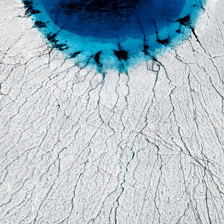
Credit: Timo Lieber.
At NASA, I spend a large portion of my work day looking at satellite images of Earth, an amazingly glorious expanded view. Go to our Beautiful Earth, Earth as Art, and Images of Change galleries (the latter is also available as an iPad app) and see for yourself. While you’re checking out our amazing images, you’ll probably also notice something that I see almost every day: Our planet is so beautiful, the images actually look like works of art.
The Earth is our home. And looking at places on the far side of our planet can give you a sense of intimacy with the whole world. That’s how my conversation with aerial photographer Timo Lieber began.
“Photography and science are a quite powerful combination,” Timo Lieber told me. We were discussing his project, THAW, a series of eleven large-scale aerial photographic images that capture the Greenland polar ice cap melting. “The extent of the melting is increasing and the net loss is worsening every single year,” he explained. “I want to put images right in front of people that show that global warming is, in fact, happening.”
“Greenland is a sensational color palette. You rarely find a landscape that’s so pristine as the Arctic.”
As a photographer, Lieber has wanted to create a body of work that explores in pictures some of the changes that are taking place in the Arctic, to translate the melting ice sheet into beautiful photographs and “to catch the viewers’ attention so that ultimately the viewer gets interested in the subject via the image.”
He teamed up with scientists from Scott Polar Research Institute at the University of Cambridge, who have been conducting research in Greenland for a number of years, and they pointed him in the direction of a series of surface melt lakes that have been increasing in size. Lieber decided to document the lakes in this exhibition of photographs.
Even though Lieber used satellite images to research the location of the lakes, once he was on the ice cap, he found “blue lakes for as far as you can see.” Because the lakes are connected, with one flowing into the other until it drops off into a moulin, he was able to follow one lake to another. “There are lakes and water literally everywhere,” he told me.

Yes, Greenland is beautiful—the ice, the lakes, the crevasses and the blues that go on and on and on. It’s a true work of art, and according to Lieber, “It’s the perfect canvas for my type of photography.”
Thank you for reading.
Laura