Earth Now Treasure Hunt

Use Earth Now to explore our planet’s vital signs. This quiz-based treasure hunt will have you delving into data layers and researching satellite missions as you seek the correct answers and learn more about planet Earth along the way.

More Info / References

1

1. Visible Earth

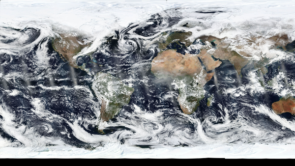
What satellite's real color images are used to create a daily mosaic selfie of Earth?

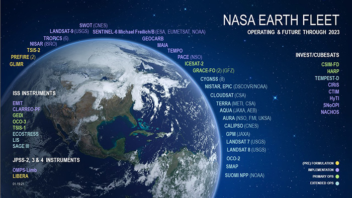
While several satellites show the true color image of our planet, in Earth Now it is the Suomi NPP satellite and its VIIRS instrument that gives users a rotatable image of what Earth looked like yesterday.
2

2. Count the Satellites

NASA Earth fleet of satellites, future and operating

How many satellites are visible orbiting Earth in Satellites Now?

NASA Earth fleet of satellites, future and operating
Another trick question! Two ways to find the answer: count the satellites on the globe or review the list under Missions. But the trick is that the GRACE-FO mission is comprised of twin satellites. Not all NASA Earth satellites are shown in Earth Now. The graphic to the right shows more missions in space and planned for the future.
3

3. Explore the Missions

Using the Missions menu, what satellite classified as studying the land has been in orbit the longest?

Trick question! The International Space Station has been in orbit about a year longer, but Terra studies the land. After more than 20 years orbiting at 705 km above Earth's surface and routinely crossing the equator at approximately the same time every day, Terra is now drifting nearing the end of its mission studying Earth. With no maneuvers planned to sustain Terra's altitude and crossing time, Terra will slowly get closer and closer to Earth - crossing the equator earlier and earlier as time passes. However, despite impacts to some of Terra's nearly 100 data products, Terra's five sensors continue to collect meaningful scientific data, producing one of the longest continuous climate data records collected by satellite.
4

4. How many orbits?

How many orbits per day around Earth does the International Space Station (ISS) make?

Use Missions > Missions Menu > ISS > then click the blue button to reveal all the details for the International Space Station. The ISS circles Earth in about 92 minutes, which equals 15.5 orbits per day.
5

5. Gravity Science

Which mission uses gravity to study the movement of water and ice?

The GRACE missions measure small month-to-month variations in gravity over Earth's surface arising from the constant redistribution of mass. Changes in how mass is distributed within and between Earth’s atmosphere, oceans, groundwater and ice sheets are fundamental indicators of the large-scale dynamics of the planet. Monitoring changes in ice sheets and glaciers, near-surface and underground water storage, the amount of water in large lakes and rivers, as well as changes in sea level and ocean currents provides an integrated global view of how Earth’s water cycle and energy balance are evolving — measurements that have far-reaching impact on our understanding of the Earth system and important applications for everyday life.
6

6. Cities Around the World

Using the More menu, what city name shown in the Earth Now application is closest to the South Pole?

This is a tough one! You must spin the globe and compare the cities. And Christchurch, New Zealand is just a bit closer to the south pole than the others. While you’re doing this, look at all the swirling cloud patterns around Antarctica. Did you know that this area of open water, an “ocean basin” has recently been named the Southern Ocean?
7

7. Looking at the Data

When visualizing sea level, what colors equate to higher sea level variation?

Select the Sea Level data set and look at the color bar. The color red indicated 88+ mm and transitions into white at 176 mm of sea level. These colors indicate regions of sea level greater than average over the last month. Sea levels rise as the ocean is heated and the sea water expands, as well as from the addition of melting ice into the ocean
8

8. Measuring Carbon Dioxide

Carbon dioxide, or CO2, is a greenhouse gas derived from human and natural activities. What is the name of the mission launched in 2014 to measure this gas contributing to climate change?

Select the Carbon Dioxide data set and learn about OCO-2. The Orbiting Carbon Observatory 2, or OCO-2, is an Earth satellite mission designed to study the sources and sinks of carbon dioxide globally and provide scientists with a better idea of how carbon is contributing to climate change.