Earth Pop Quiz

How much do you know about Earth and Earth-observing systems?

Take the quiz to find out.

More Info / References

1

1.

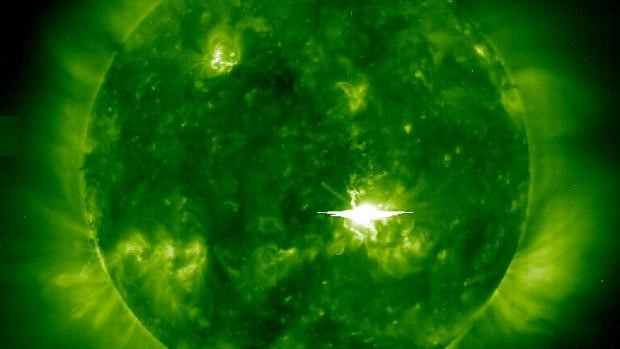
What is causing the bright flash in this ESA/NASA Solar and Heliospheric Observatory Ultraviolet image?

A solar flare is an intense burst of radiation coming from the release of magnetic energy associated with sunspots. Solar flares impact Earth only when they occur on the side of the sun facing Earth. Because flares are made of photons, they travel out directly from the flare site, so if we can see the flare, we can be impacted by it.
2

2.

This photo, taken in at Cape Point, South Africa in November 2007, captures a GAWS. What does GAWS stand for?

GAWS is a worldwide system established by the World Meteorological Organization to monitor trends in the Earth's atmosphere.
3

3.

This 2005 Landsat image shows the Swedish Island of Gotland in the Baltic Sea and the waters around the island. What is depicted in the greenish waters?

Also called algae blooms, a phytoplankton bloom takes place when a species of phytoplankton reproduces at a rapid rate, multiplying quickly in a short amount of time. Harmful algal blooms, or HABs, occur when colonies of algae—simple photosynthetic organisms that live in the sea and freshwater—grow out of control while producing toxic or harmful effects on people, fish, shellfish, marine mammals, and birds. HABs are a national concern because they affect not only the health of people and marine ecosystems, but also the 'health' of local and regional economies.
4

4.

This 2009 EO-1 satellite image features Tikehau Atoll. It is one of 78 coral atolls that make up the Tuamotu Archipelago, the largest chain of atolls in the world. Where is this atoll?

French Polynesia is an overseas collectivity of France consisting of five archipelagoes in the south-central Pacific Ocean.
5

5.

What does the acronym SMAP stand for, in NASA’s SMAP satellite mission?

The Soil Moisture Active Passive satellite measures the amount of water in the top 5 cm (2 inches) of soil everywhere on Earth’s surface. The data can improve weather forecasts, monitor drought, and predict floods.
6

6.

To determine the severe weather potential of a thunderstorm, which of the following describe the best way to utilize GOES-R data?

Using satellite data along with ground-based radar and lightning data can help better predict a thunderstorm’s potential to produce severe weather.
7

7.

What is this ocean observing technology?

A wave buoy is used to measure the movement of ocean water, specifically the significant wave height, wave period, and wave direction. The United States Army Corps of Engineers, SCRIPPS, and the US Integrated Ocean Observing System operates more than 70 of these types of wave buoys.
8

8.

The Thematic Mapper I instrument in some of the Landsat satellites has a spatial resolution of 30m in the VIR (Visible and Infrared) bands, and of 120m in the TIR (Thermal Infrared) bands. What is the reason for this difference?

The Thematic Mapper (TM), is an advanced, multispectral scanning, Earth resources sensor on Landsat. The TM sensor is designed to achieve higher image resolution, sharper spectral separation, improved geometric fidelity and greater radiometric accuracy and resolution than the MSS sensor. TM data are sensed in seven spectral bands simultaneously.
9

9.

Why is it important to monitor seabird colonies?

Indicator species can signal a change in the biological condition of an ecosystem and can be used as a proxy to diagnose the health of that ecosystem
10

10.

What is the main objective of USGEO?

The U.S. Group on Earth Observations (USGEO) is a subcommittee of the White House Office of Science and Technology Policy’s Committee on Environment. USGEO leads U.S. federal efforts to enable a healthy public, environment, and planet through integrated, comprehensive, and sustained Earth observations. USGEO also supports the international organization, the Group on Earth Observations (GEO).