News | July 20, 2009
El Niño, now and then

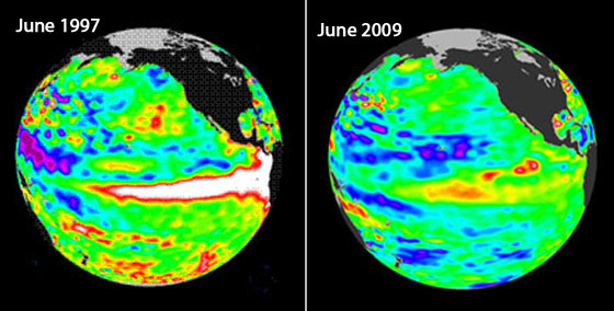
The Topex/Poseidon satellite image on the left shows details about sea surface height in the eastern equatorial Pacific from June 1997, months before the historic 1997-1998 El Niño event. The image on the right, from NASA's Jason-2, shows conditions in June of this year.
These satellite images show details about sea surface height in the eastern equatorial Pacific from June 1997, months before the historic 1997-1998 El Niño event, and from June of this year. Places where the Pacific sea-surface height is higher (warmer) than normal are yellow and red, and places where the sea surface is lower (cooler) than normal are blue and purple.
During an El Niño year, trade winds that normally blow westward along the equator die down and warm surface waters begin to pile up along the eastern side of the equatorial Pacific. The warmer surface water appears as the large red and white band in the June 1997 image.
The orange and red bands in the June 2009 image are also an indication of warmer water and show a transition to El Niño conditions. The warming is not as intense as in June 1997, so this El Niño is expected to be less dramatic.
El Niño is a global phenomenon, with the warmer water bringing severe flooding to some areas while other parts of the globe experience drought. According to NOAA scientists, El Niño conditions in the Pacific Ocean will continue to develop and are expected to last through the Northern Hemisphere winter 2009-2010.
