News | September 25, 2012
Study examines forest vulnerability to climate change

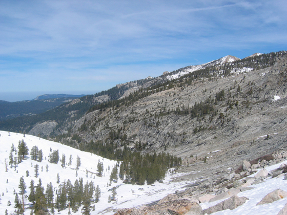
A Sierra Nevada forest in Sequoia National Park, Calif. Forest patterns are correlated to snow depth. Image credit: University of Colorado, Boulder
By Alan Buis,
Jet Propulsion Laboratory
and Noah Molotch,
CU-Boulder
Mid-elevation forests - those between approximately 6,500 to 8,000 feet (1,981 to 2,438 meters) in elevation - are the most sensitive to rising temperatures and changes in precipitation and snowmelt associated with climate change, finds a new University of Colorado Boulder-led study co-funded by NASA. The study looked at how the greenness of Western U.S. forests is linked to fluctuations in year-to-year snowpack.
A research team led by CU-Boulder researcher Ernesto Trujillo used satellite and ground data to identify the threshold where mid-elevation forests that are sustained primarily by moisture transition into higher-elevation forests that are instead sustained primarily by sunlight and temperature. The team used 26 years of continuous data from the Advanced Very High Resolution Radiometer (AVHRR), a spaceborne sensor flying on a National Oceanic and Atmospheric Administration satellite, to measure forest greenness. Forest observations from NASA's Moderate Resolution Imaging Spectroradiometer (MODIS) instrument on NASA's Terra spacecraft were critical for evaluating the longer-term AVHRR data.
Being able to identify this "tipping point" is important because many people live and play in these mid-elevation forests in the Western United States, said co-author Noah Molotch, CU-Boulder assistant professor and also a research scientist at NASA's Jet Propulsion Laboratory, Pasadena, Calif. These forests are seeing higher levels of wildfires, beetle outbreaks and tree mortality.
The researchers found that these mid-elevation forests show a dramatic sensitivity to snow that fell the previous winter, both in terms of accumulation and subsequent melt. About half of the mid-elevation forest greenness measured by satellites was attributed to the snow accumulations from the previous winter, with the other half due to conditions such as soil depth, soil nutrients, temperature and sunlight. "The strength of the relationship between forest greenness and snowpack from the previous year was quite surprising to us," Molotch said.
"Our results provide the first direct observations of snowpack-forest connections across broad spatial scales," said Molotch. "Finding the tipping point between water-limited forests and energy-limited forests defines for us the region of the greatest sensitivity to climate change - the mid-elevation forests - which is where we should focus future research."
While this study took place in California's Sierra Nevada Mountains, Molotch said it is applicable to other mountain ranges across the Western United States. The implications are important, since climate studies indicate the snowpack in mid-elevation forests in the Western United States and other similar forests around the world has been decreasing in the past 50 years due to regional warming.
"If snowpack declines, forests become more stressed, which can lead to ecological changes that include alterations in the distribution and abundance of plant and animal species, as well as vulnerability to perturbations like fires and beetle kills," Molotch said.
"When you put this into the context of recent losses in Colorado and elsewhere in the West to forest fire devastation, then it becomes something we really have to pay attention to," Molotch said. "This tipping-point elevation is very likely to migrate up the mountainsides as the climate warms."
Molotch said the connections the team observed between water availability and forest response have important implications for current and future NASA missions focused on forest structure, soil moisture and snow. NASA's Terra, Aqua and Suomi spacecraft have sensors that measure components of the water cycle and vegetation that can be used to explore the mechanisms behind the study's results. Among the future NASA missions that can contribute to our understanding of connections between snowpack and ecosystems are the JPL-managed Soil Moisture Active Passive spacecraft and NASA's planned synthetic aperture radar satellite mission.
The paper was published earlier this month in Nature Geosciences. The National Science Foundation also provided funding. Other participating institutions included the University of California, Irvine; and the University of California, Merced.
For more on the study, read the full CU-Boulder news release at:
