News | March 26, 2017
NASA tests observing capability on Hawaii's coral reefs
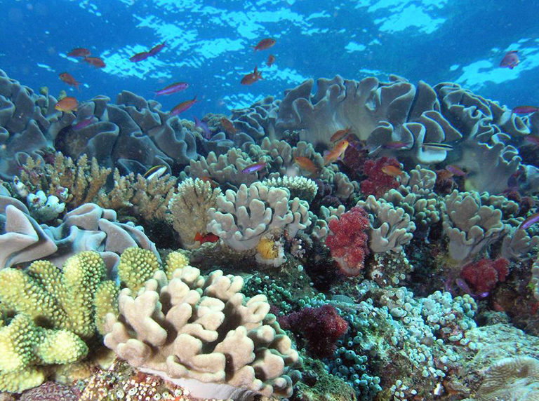
NASA coral reef studies in Hawaii this winter will help scientists understand this unique environment. Credit: NOAA.
NASA pulled off a scientific double play in Hawaii this winter, using the same instruments and aircraft to study both volcanoes and coral reefs. Besides helping scientists understand these two unique environments better, the data will be used to evaluate the possibility of preparing a potential future NASA satellite that would monitor ecosystem changes and natural hazards.
The advantages of studying active volcanoes from the air rather than the ground are obvious. Coral reefs may not offer the same risks in a close encounter that volcanoes do, but there's another good reason to study them by remote sensing: they're dotted across thousands of square miles of the globe. It's simply not feasible to survey such a large area from a boat. So NASA has been monitoring coral reefs by satellite and aircraft for several decades. Recent airborne efforts have used sensors that provide better spatial and spectral resolution than currently available from NASA satellite systems.
"Reefs are threatened by bleaching due to rising sea surface temperatures as well as, to some degree, by increasing acidification of ocean waters,” said Woody Turner of NASA Headquarters in Washington, the program scientist for the recent Hawaii study. “On top of that, since they're coastal ecosystems, they are also subject to sediment and other effluents running offshore. We have an urgent need to get a handle now on how reefs are changing."
Over the past four years, NASA has flown a series of research flights over California, carrying airborne prototypes of instruments in preparation for a possible future satellite mission called the Hyperspectral Infrared Imager (HyspIRI), now in the conceptual design phase. The Golden State has many diverse landscapes to test the instruments' observational capabilities, but not coral reefs or erupting volcanoes. This winter's HyspIRI Hawaii field campaign filled that gap.
To get the next best thing to a satellite's point of view, HyspIRI Hawaii used a high-altitude ER-2 aircraft from NASA’s Armstrong Flight Research Center, Palmdale, California. During the study, the aircraft was based at Marine Corps Base Hawaii, on the island of Oahu. Flying at approximately 60,000 feet (18,000 meters) and thus above most of Earth's atmosphere, the ER-2 carried the Airborne Visible and Infrared Imaging Spectrometer (AVIRIS), developed by NASA’s Jet Propulsion Laboratory, Pasadena, California, and the MODIS-ASTER Airborne Simulator (MASTER), developed by NASA’s Ames Research Center, Moffett Field, California. AVIRIS is an imaging spectrometer that observes the complete reflected spectrum of light in the visible and shortwave infrared wavelengths. MASTER has multiple observational channels in the thermal infrared wavelengths. Together AVIRIS and MASTER provide the same combination of spectral bands planned for the future HyspIRI mission — and powerful data for current coral reef research.
Six coral reef-related projects with diverse objectives are using imagery that AVIRIS and MASTER collected around the Hawaiian archipelago in January through early March.
• Under principal investigator Steven Ackleson (U.S. Naval Research Laboratory, Washington), a team investigated how coral reefs and water quality vary, in both space and time, over the huge distance encompassed by the Hawaiian Islands and the 1,200-mile-long (2,000-kilometer-long) Papahanaumokuakea Marine National Monument north of the main islands. Ackleson's team used the airborne instruments and in-water observations to collect data on reef condition and water quality and compared them with data collected from 2010 to 2014 with a different hyperspectral imager.
• To study reefs' responses to stress, Kyle Cavanaugh (UCLA) led a study of the composition of shallow reefs (coral, algae and sand) and the extent of their bleaching. The team hopes to uncover the practical limits of the proposed HyspIRI instrument in observing these features. Like Ackleson's and most of the other investigators' projects, this study combined airborne imagery with ocean measurements.
• Heidi Dierssen (University of Connecticut) used in-water spectrometers in conjunction with the airborne AVIRIS imaging spectrometer products to look at pigment differences among corals’ photosynthetic algae, known as zooxanthellae. A goal is to determine the degree to which differences in pigment — which relate to different types of algae with different biological characteristics and responses to environmental change — can be detected from an airborne platform and ultimately from space.
• To determine how changes in a reef's environment — cloudiness, water temperature, water murkiness — might affect coral health, and how these environmental factors themselves might be influenced by changing land use on the islands, Paul Haverkamp (supported by Cramer Fish Sciences, West Sacramento, California) will be comparing this year's AVIRIS data with observations from AVIRIS campaigns flown between 2000 and 2007. The study focuses on reefs in Kaneohe Bay, Oahu, and Kealakekua Bay, Hawaii.
• Eric Hochberg (Bermuda Institute of Ocean Sciences) and his team will compare this year's AVIRIS measurements with AVIRIS data from 2000 to study how human and climate stresses may be affecting reefs around the islands. They will quantify reef composition and primary productivity and correlate them with oceanographic conditions, land use and land cover on the islands, and local human threats to investigate how the reefs' condition and relationship to their environments may have changed in the last 16 years.
• ZhongPing Lee of the University of Massachusetts, Boston, took field measurements of reefs concurrently with the HyspIRI flights, using a special system that precisely measures the spectrum of colors in ocean water, which provides important information about what's in the water. Lee and his team measured the shape of the seafloor, the water's optical properties, and other characteristics to compare with the same measurements made by AVIRIS.
Get a 360-degree view of the ER-2 landing on Oahu during the HyspIRI Hawaii mission:
https://www.youtube.com/watch?v=Zwkr-nsbaus&feature=youtu.be


