Ask NASA Climate | September 18, 2014, 09:48 PDT
But wait … wait … there's more!
Get one Earth mission or collect them all
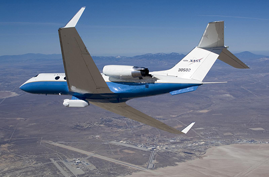
NASA's C-20A (G-III) banks over Edwards Air Force Base, Calif., carrying the UAVSAR underbelly pod, in preparation for studying U.S. and international volcanoes. Credit: Lori Losey, NASA
Everyone I know who works in Earth science at NASA feels compelled to spread the following message: Sure, NASA explores space—but hey, we study Earth too.
When I first started working here, it seemed like very few people were listening. But, awareness changed and the world started to notice how much we’re doing. Nowadays almost everyone I meet seems to know that NASA studies Earth. So this caused our goals to expand. We want people to know that NASA has a whole fleet of Earth-orbiting satellites that measure everything from clouds to sea surface height to carbon dioxide concentration. What’s more, this year we're launching five new satellites within 12 months. Hey people of Earth, listen up. We’re on it!
Mission accomplished, right? Well, almost … (Insert sound of scratching record)
(Before I continue, I have to tell you how I really feel: I’m caught between behaving like one of those guys on an infomercial who keeps yelling: “wait, there's more!” and my discomfort with interminable bragging. But since there really is so much more, I’ll solve the conundrum by telling you that I just took a five-minute break to dance awkwardly in my small office to pop music. This proves that despite the fact that NASA has many impressive achievements, it is also made up of real people, and some of us are secret awkward office dancers.)
Okay then, now it’s time to head for Awesome Town, to let fly the “wait … wait … there’s more!”
In addition to 17 satellites currently orbiting Earth, we at NASA also have an Airborne Science Program. “An Airborne Science Program?" you might ask. "What’s that?” Basically, it’s a NASA plane with a NASA instrument mounted on it that scientists all around the country can use. Cooooool.

There are a bunch of reasons why NASA wants to fly airplanes, even though we have access to space. First, a plane can make regional-scale measurements to add to ground- and space-based ones. Measurements of complex regional processes help us understand the complete Earth system when added to global satellite observations. Airborne missions also calibrate measurements that the Earth-observing satellites make, as well as test and refine new instrument technologies before they go to space, which reduces risk.
But wait, there’s more! NASA has roughly 25 airborne science programs currently active.
See why I feel like an infomercial?
Earlier this month, a few of my co-workers in science communications got to fly along on an airborne mission called UAVSAR, which stands for Uninhabited Aerial Vehicle Synthetic Aperture Radar. It’s an imaging radar instrument that can determine how land features have changed. The radar pod is mounted beneath a Gulfstream-III C20-A environmental science research aircraft (not quite "fly like a G6" but still pretty sweet). It penetrates snow, brings out terrain features, shows glacier flow, measures soil moisture, studies river flooding and effect on levees, and changes in earthquake faults. The plane flies swaths back and forth over the same area, like a lawn mower mowing a lawn. Scientists compare two UAVSAR radar images of the same location to look for changes.

That day there were two pilots on board, one flight coordinator, one radar operator and three stooges, ahem, I meant three observers. In six hours, they flew 3,000 miles and never left California. They looked at the San Andreas Fault, measured soil moisture in the Central Valley and spent most of the time surveying levees in the Sacramento Delta and San Francisco Bay.

But wait, there’s more … and if you want to find out about it check out these links:
https://airbornescience.nasa.gov/program/current_activities
A sampling of features about UAVSAR missions can be found at:
http://www.nasa.gov/centers/armstrong/news/FactSheets/FS-074-DFRC.html
As always, I appreciate your comments.
Laura