By Ellen Gray,
NASA's Goddard Space Flight Center

Ganges River Delta, imaged on February 1, 2000 by Landsat 7. The Ganges River forms an extensive delta where it empties into the Bay of Bengal. The delta is largely covered with a swamp forest known as the Sunderbans, which is home to the Royal Bengal Tiger. Credit: USGS/EROS.
Richat Structure, imaged on January 1, 2001 by Landsat 7. The so-called Richat Structure is a geological formation in the Maur Adrar Desert in the African country of Mauritania. Although it resembles an impact crater, the Richat Structure formed when a volcanic dome hardened and gradually eroded, exposing the onion-like layers of rock. Credit: USGS/EROS.
Ice Waves, imaged on May 21, 2001 but Landsat 7. Along the southeastern coast of Greenland, an intricate network of fjords funnels glacial ice to the Atlantic Ocean. During the summer melting season, newly calved icebergs join slabs of sea ice and older, weathered bergs in an offshore slurry that the southward-flowing East Greenland Current sometimes swirls into stunning shapes. Exposed rock of mountain peaks, tinted red in this image, hints at a hidden landscape. Credit: USGS/EROS.

During a span of 40 years, since 1972, the Landsat series of Earth observation satellites has become a vital reference worldwide for understanding scientific issues related to land use and natural resources.

To celebrate the 40th Anniversary of Landsat, the U.S. Geological Survey (USGS) and NASA would like your help in selecting the top five "Earth as Art" images from the more than 120 images in the complete collection.

The poll is now open. It closes on July 6.

More information and details on how to cast your vote.

Earth as Art’s Top Five will be announced on July 23 in Washington, D.C. at a special event commemorating the launch of the first Landsat satellite.

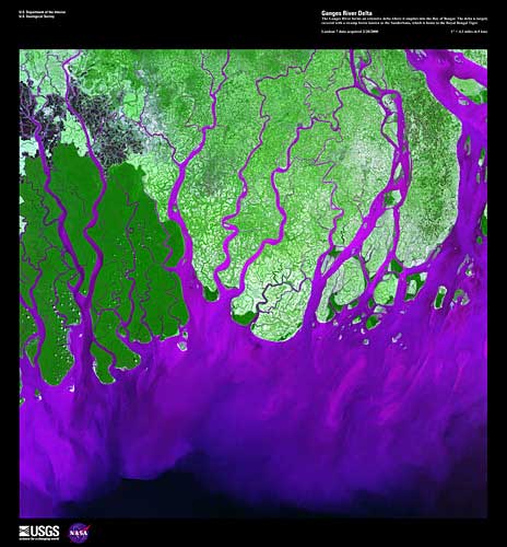
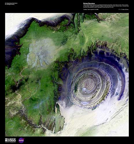
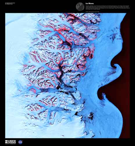
Built by NASA and operated by USGS, Landsat satellites supply Earth scientists, land-resource managers, and policy makers with objective data about changes across the global landscape. Some changes, like major floods or volcanic eruptions, come quickly; others, like urban sprawl or regrowth from forest fires, appear gradually. Landsat impartially records these and many other changes to the land that are induced by man or nature.

Beyond the scientific information they confer, some Landsat images are simply striking to look at — presenting spectacular views of mountains, valleys, and islands; forests, grasslands, and agricultural patterns. By selecting certain features and coloring them from a digital palate, the USGS has created a series of "Earth as Art" perspectives that demonstrate an artistic resonance in land imagery and provide a special avenue of insight about the geography of each scene.

NASA is preparing to launch the next Landsat satellite in 2013, which will be turned over to USGS for operations and data distribution.

Cast your vote for the Best of Earth As Art here.

For more information about the Landsat Program, visit the NASA Landsat page.