News | September 12, 2012
Grace mission offers a novel view of Earth's water supplies

Two ranchers walk across the plains of drought-stricken West Texas in July 2011. (Photograph courtesy U.S. Department of Agriculture.)
By Holli Riebeek,
Earth Observatory
The signature of drought was easy to read in the southern United States in the summer of 2011. It was in the brown, wilted crops and the bare fields. It was in the clouds of dust that rolled across the sky and in the shrinking reservoirs. It was in the fires that raced through crisp grasslands and forests, devouring homes and wilderness. It was in the oppressive heat that returned day after day.
Drought was harder to see as 2011 drew to a close. With the return of winter, rains began to fall and temperatures dropped. But the drought was still there, lingering beneath the surface. It was still apparent to hydrologists who test the wells that plunge deep into underground aquifers.
This lingering, subtle drought was also visible to a highly unusual pair of satellites.
In Nebraska, Brian Wardlow and colleagues at the National Drought Mitigation Center watched the drought long before and after the average citizen paid heed. Wardlow develops satellite-based products that experts use—along with more traditional ground observations—to assess the severity of drought. Looking at measurements from the satellites, Wardlow could see broad-scale changes in groundwater supplies at varying depths over large swaths of the South.
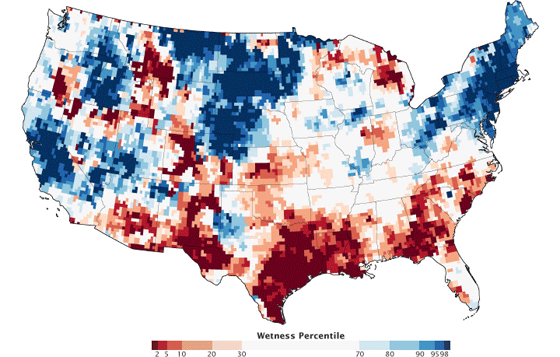
After a year without much rain, it was no surprise that the drought lingered below the land’s surface. “Groundwater takes a long time to be depleted, but it takes a long time to be recharged as well,” says Wardlow, a remote sensing specialist at the University of Nebraska–Lincoln. From experience, he expected regional groundwater supplies to be diminished. But this time he could see it in greater detail than traditional well measurements had ever provided.
Now a scientist at NASA’s Goddard Space Flight Center, Rodell has spent the past decade studying groundwater with Grace and working to make those measurements useful to decision-makers. Thanks largely to Famiglietti, Rodell, and a handful of other scientists, Grace’s measurements of groundwater, ice, and oceans are now so essential that NASA is preparing to launch a follow-on mission.