News | February 24, 2016
NASA, partner space agencies measure forests in Gabon
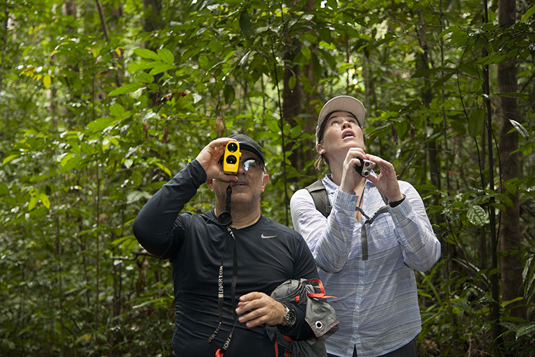
Members of the AfriSAR team, Sassan Saatchi (left) from NASA's Jet Propulsion Laboratory and Laura Duncanson (right) from NASA's Goddard Space Flight Center take measurements of trees in the rainforest in the Mondah National Park, Gabon. Credit: NASA/Carla Thomas.
A contingent of NASA airborne instruments and scientists on the ground, including some from NASA’s Jet Propulsion Laboratory, Pasadena, California, has joined colleagues from space agencies in Gabon and Europe this month to study the dense African tropical forests in Gabon.
Gabon, a Central African country slightly smaller than the state of Colorado with a population of about 1.5 million, is home to one of the most pristine rainforests on our planet. During the two-week-long NASA campaign, in collaboration with a European Space Agency (ESA) mission called AfriSAR, researchers are collecting measurements of plant mass, distribution of trees, shrubs and ground cover, and diversity of plant and animal species — not only from Gabon’s rainforest but also from the country’s wetlands, mangrove forests and savanna. ESA launched the first part of the AfriSAR field campaign in Gabon in July 2015, when teams led by the French national aerospace research center collected radar and field measurements of the country’s forests. Now NASA and the German Aerospace Center (DLR) have joined the second leg of the campaign.

“One of the questions we’re really interested in at NASA is balancing the global carbon budget,” said Lola Fatoyinbo, a research scientist at NASA’s Goddard Space Flight Center in Greenbelt, Maryland, and lead of NASA’s contribution to the AfriSAR campaign. “We know how much carbon dioxide is being emitted into the atmosphere by fossil fuel emissions, but we don’t have a good estimate of how much carbon is being taken up from the atmosphere and where it’s stored — we think that forests absorb about a quarter of all these emissions, but we need better studies of forest biomass to confirm this.
“With AfriSAR, we’re getting very accurate measurements of the 3D structure of an ecosystem that is representative of the larger Congo Basin rainforest and of tropical forests in general, and this is going to allow us to get a better grip on how much carbon is stored in these ecosystems,” Fatoyinbo said.
Gabon’s forest is part of the Congolian tropical forests, altogether the second largest rainforest in the world after the Amazon. About 85 percent of the country’s land is forest.

During the AfriSAR campaign, UAVSAR flies 40,000 feet high mounted beneath a C-20A aircraft from NASA’s Armstrong Flight Research Center in Edwards, California. LVIS flies at 28,000 feet onboard a B-200 airplane from NASA’s Langley Research Center in Hampton, Virginia. Both instruments collect measurements of surface topography and vegetation structure by sending out rapid pulses of either radio waves (UAVSAR) or laser light (LVIS) toward their targets. They then calculate the distance to objects below by measuring how long it takes for the signal to bounce back, creating 3D maps of the surface beneath.
“LVIS studies the vertical structure of the forests by measuring the elevation of everything the photons hit: the top of the canopy, all of the leaves and branches and finally the ground,” said Blair, principal investigator and developer of LVIS. “In tropical forests, the challenge is to get the laser pulse all the way to the ground because the whole canopy is closed; there’s very few holes for the photons to get through.”
The data collected by LVIS will help calibrate and validate the information gathered by UAVSAR over the same targets, and vice-versa. The two datasets will also be compared to the airborne radar measurements that ESA and DLR are compiling during their current campaigns in Gabon. Finally, AfriSAR’s ground teams from Goddard and JPL are performing several types of field measurements, such as tree width, forest structure and soil moisture, which will complement and refine the data gathered from the air.

Furthermore, the forest data gathered in Gabon might help to inform policymakers working on climate mitigation and forest conservation policies, Saatchi said.
AfriSAR is NASA’s first collaboration with Gabon’s young space agency, AGEOS, and also its first large international campaign in Africa since NASA participated in a hydrological study of the Sahel in the early 1990s.
For more on UAVSAR, visit:
For more on NISAR, visit:
Media contact
Alan Buis
Jet Propulsion Laboratory, Pasadena, Calif.
818-354-0474
Alan.buis@jpl.nasa.gov


