Ask NASA Climate | October 15, 2014, 12:23 PDT
Looking at clouds from both sides
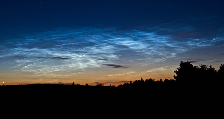
Pictured here are rare clouds, technically called "noctilucent" or "polar mesospheric" clouds, spotted over Billund, Denmark on July 15, 2010. Credit: Jan Erik Paulsen. View and download large image.
Anyone passing by must have thought I was a bit nutty standing in the road and gazing into the sky on a Tuesday afternoon, but it was all for science. That’s right: citizen science.
A “citizen scientist” is a member of the public who makes careful field observations and contributes data toward professional scientific research. Wanna try it? You can. NASA is inviting everyone to participate in a citizen science project, called “#SkyScience,” for Earth Science Week 2014, October 12-18. Earth Science Week is an international event organized by the American Geosciences Institute to help people better understand and appreciate the Earth sciences and to encourage stewardship of our planet.
So I was standing in the road doing #SkyScience, observing all the clouds in the sky—both the ones overhead and the ones off in the distance.
You can do citizen science and help NASA scientists by joining the #SkyScience program. You have to look up at clouds at the same moment a NASA satellite is looking down.
When you first visit the SkyScience S’COOL website, you might think it’s predominantly for kids but, trust me, you should check it out. It’s interesting and fun, and you’ll likely learn something, no matter your age.
When you’re at the website, the first thing you have to do is find your satellite overpass time; that way, you can schedule your cloud observation. This involves clicking on a map that gives you your latitude and longitude coordinates and inputting the dates you want to make your observations. The website will then generate the satellite overpass schedule, which you will receive via email a few seconds later. I’ve never known my exact lat/long coordinates, so I was somewhat psyched by this part of the process.
Getting my head in the clouds
To be honest, the citizen science projects I’d participated in before had imprecise data collection processes, and I’d doubted the accuracy of the untrained citizens’ measurements. In this case, even the first step was so well organized that it seemed practically impossible to get erroneous timing.
The next step is to go outside within a 30-minute window and observe the clouds. “Aha! That’s where the untrained bad measurements come in,” you might say. And I say back to you, “Don’t be so quick to critique.” Here’s the deal: I’ve looked at cloud charts many times, but this time was different. This time I had to look at actual clouds in the actual sky and identify those specific clouds. I had to interact with a chart, which forced me to understand it. It forced my mind to see the clouds in a different way; it forced me to learn.
The cloud reporting documents were thorough enough to weed out any shirkers who thought they might get away with shoddy cloud observations, although documenting the observations and submitting them online took about half an hour and were easy to do.
NASA announced #SkyScience on October 1, and since then we’ve received about 2,500 overpass requests and more than 360 submitted cloud observations, and we’re hoping for more.
I spoke with Lin Chambers, S'COOL project director, to make sure the submitted #SkyScience observations and photos don’t end up in the back corner of a file cabinet somewhere.
She’s hoping to get observations from places that have snow on the ground. “Even a four-year-old on the ground has no problem telling the difference between snow on the ground and clouds in the sky, but for a NASA satellite doing remote sensing, that’s one of the biggest challenges.”
Chambers explained that she and her team are looking for ways to make the satellite measurements as accurate as possible. “When you’re on the ground looking up, you have a uniform blue sky to detect against, but when you’re in space, you’re looking down at the surface, which has all sorts of variability.”
As long as you observe the sky within 15 minutes of the satellite overpass, you’ll get an email within about five days that matches your observation with the satellite’s. You can find a record of your observations, along with all the other ground observations, and compare the clouds you saw with the corresponding satellite data. At that point you’ll have seen the same clouds from both sides: from the bottom and from the top.